Version 2.5 · Available now on iOS and Android

See the whole grid, not just their street.

WeatherAlarm watches the places your people actually are — a parent's house, a kid's campus — and tells you what the sky is doing there. Version 2.4 told you when their lights went out. Version 2.5 shows you the outage spreading across the map, lets you read the wind from the instruments nearest them, and puts a pin on the houses an address search has never been able to find.

Available now on the App Store and Google Play.

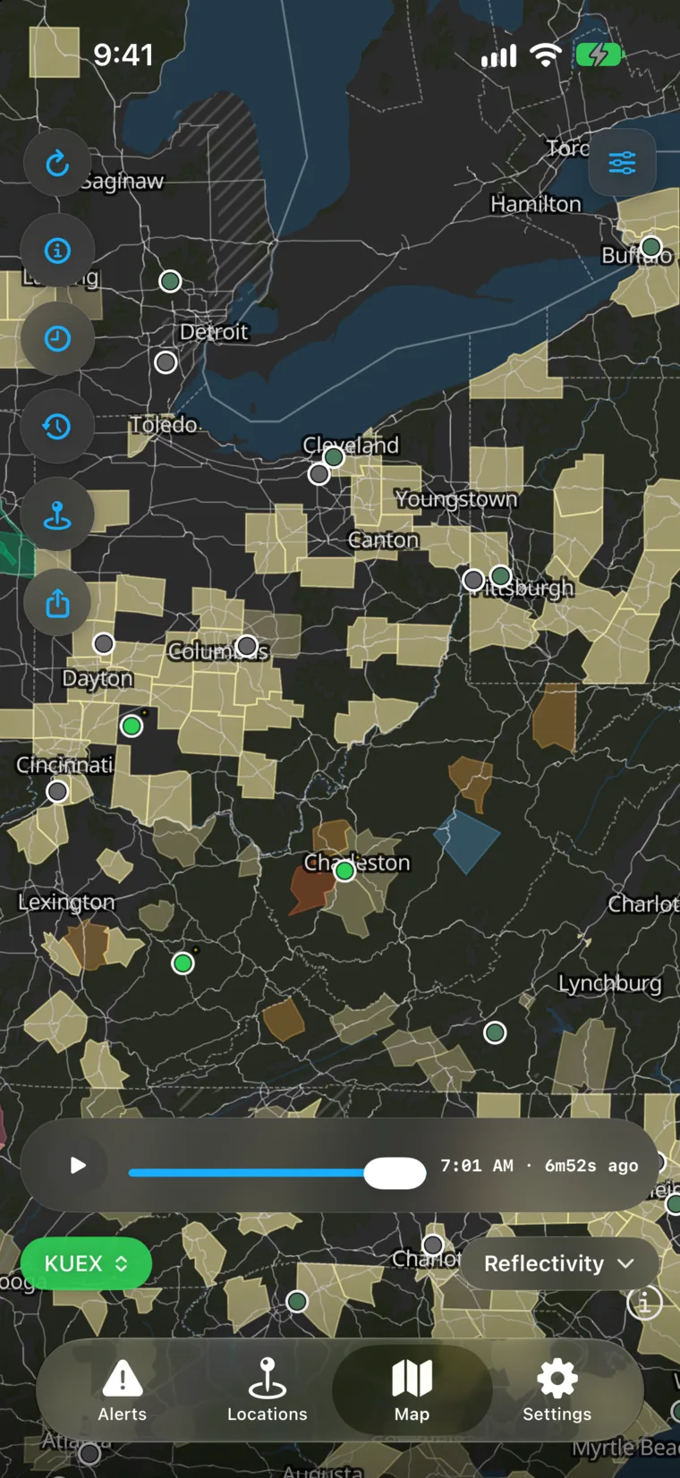
WeatherAlarm’s map over Ohio, Pennsylvania and West Virginia with the power-outage layer on: dozens of counties shaded by the share of tracked customers who are out, a handful darker around Charleston, and hatching over the counties nobody publishes an outage feed for.

The biggest improvements

The map now shows what the storm took with it.

Version 2.5 widens the view: from one address to the whole country's power, from a forecast to the wind a real instrument is measuring, and from an address search to a pin you place yourself.

Power outages, county by county

A new map layer shades the country by how much of each county is dark, drawn from hundreds of utilities’ own live feeds. Tap a county for who is reporting it and how many homes are out. Counties nobody publishes for are marked as unknown rather than quietly coloured calm.

The wind a real instrument is reading

Weather stations appear on the map as live chips — current wind, coloured by how hard it is blowing, with an arrow for direction. Radar shows you where the rain is; it never showed you that the airport four miles from Mom is gusting to 45. Tap a chip for that station’s whole day.
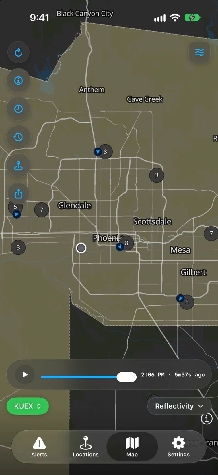
WeatherAlarm’s map over Phoenix with weather stations shown as live chips — each one a wind speed in miles per hour with an arrow for the direction it is blowing from.

A pin for the house with no address

Some homes an address search simply cannot find — a farmhouse down an unnamed road, a cabin, a new build. Now you can drop a pin exactly where they live, or paste a map link someone sent you, and watch that spot instead.
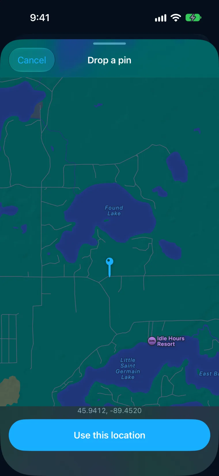
WeatherAlarm’s Drop a pin screen over lake country in northern Wisconsin: unnamed roads between Found Lake and Little Saint Germain Lake, a pin placed on a spot with no street address, and its coordinates shown above a Use this location button.

In detail

The details matter.

Smaller changes, chosen because they answer a question someone actually asked while watching a storm.

Power, at any scale

  • Every county we can seeThe outage layer shades each county by the share of tracked customers who are out, and names the utilities reporting it. Hundreds of providers, read live from their own public feeds.
  • Unknown is not the same as fineRoughly two thirds of US counties have no public outage feed at all. Those are drawn as unknown, never as calm — an empty map should never read as an all-clear.
  • Always named, never anonymousEvery figure names the utility it came from, so you can judge the source and go straight to them.
  • And still the card for their addressEverything 2.4 did on a loved one’s card is unchanged — the street-level claim where a utility publishes one, the neighbourhood share where it does not, and silence where we cannot see.
  • Tap a county, get the whole pictureWhere a county is under a watch and losing power at the same time, tapping it now asks which you meant instead of showing only the watch.

Wind you can check

  • Live chips on the mapEach station shows what it is measuring right now, coloured by strength, with an arrow for direction — the observation that radar has never been able to give you.
  • A station’s whole dayTap a chip for temperature, dew point, humidity, pressure, visibility, wind and gusts, each opening a 24-hour chart. The station you tapped is the station you get.
  • Drag to read any momentTouch the chart and move along it; the scrubber follows your finger and reads out the value at that time. Gusts stay separate from sustained wind, because a null gust means none was reported, not zero.
  • Only the ones you can hitA station chip opens only when you press the dot itself. It no longer steals a tap meant for the radar site beside it — which, at an airport, is almost always right beside it.

Adding a place, and reading it

  • Drop a pin where they actually liveFor a house no address search can find, place the pin yourself and confirm it. The map shows you exactly what you are about to watch.
  • Paste the map link they sent youSomeone shares a location from their phone; paste it in and WeatherAlarm resolves it to the spot.
  • The river’s forecast crestA card can carry where the nearest gauge is expected to peak, not just where it stands now.
  • Heat, and roads that refreezeDangerous heat is called out, and so is the hour wet roads are expected to freeze over — the overnight hazard that looks like nothing on a forecast.
  • What is actually going to fallExpected rain or snow totals, and the gusts ahead, read straight from the forecast for their place.

Alerts that behave

  • An updated warning says what changedWhen the Weather Service reissues a warning, the card tells you what actually moved — rather than looking like a second, separate storm.
  • Hidden alerts end up where you expectAnything you hide now settles into Expired instead of its own separate list, so there is one place to look back at.
  • Escalations still come back on their ownIf a warning you hid is later upgraded, it returns by itself. Hiding has never affected whether a notification reaches you.
  • Faster to get back to where you wereLocations and Alerts remember where you had scrolled to and return you there, instead of snapping back to the top every time.

Severe weather alerts for the people you love.

Free. No ads, no tracking, no paid tier. Add the places that matter and WeatherAlarm watches them around the clock.